


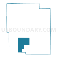
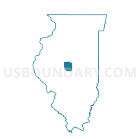
ELKHART 1 Voting District, Logan County, Illinois
About
Outline

Summary
| Unique Area Identifier | 572686 |
| Name | ELKHART 1 Voting District |
| County | Logan County |
| State | Illinois |
| Area (square miles) | 35.67 |
| Land Area (square miles) | 35.67 |
| Water Area (square miles) | 0.00 |
| % of Land Area | 100.00 |
| % of Water Area | 0.00 |
| Latitude of the Internal Point | 40.00324610 |
| Longtitude of the Internal Point | -89.43512580 |
Maps

Graphs
Select a template below for downloading or customizing gragh for ELKHART 1 Voting District, Logan County, Illinois


Neighbors
Neighoring Voting District (by Name) Neighboring Voting District on the Map
- BROADWELL Voting District, Logan County, IL
- BUFFALO HART Voting District, Sangamon County, IL
- CHESTER Voting District, Logan County, IL
- CORWIN Voting District, Logan County, IL
- ELKHART 2 Voting District, Logan County, IL
- HURLBUT Voting District, Logan County, IL
- MT PULASKI 3 Voting District, Logan County, IL
- MT PULASKI 4 Voting District, Logan County, IL
- WILLIAMS 1 Voting District, Sangamon County, IL
- WILLIAMS 2 Voting District, Sangamon County, IL
Top 10 Neighboring County Subdivision (by Population) Neighboring County Subdivision on the Map
- Broadwell township, Logan County, IL (3,549)
- Williams township, Sangamon County, IL (3,446)
- Mount Pulaski township, Logan County, IL (2,100)
- Chester township, Logan County, IL (669)
- Corwin township, Logan County, IL (643)
- Elkhart township, Logan County, IL (511)
- Hurlbut township, Logan County, IL (305)
- Buffalo Hart township, Sangamon County, IL (173)
Top 10 Neighboring Place (by Population) Neighboring Place on the Map
Top 10 Neighboring Elementary School District (by Population) Neighboring Elementary School District on the Map
Top 10 Neighboring Secondary School District (by Population) Neighboring Secondary School District on the Map
Top 10 Neighboring Unified School District (by Population) Neighboring Unified School District on the Map
- Williamsville Community Unit School District 15, IL (7,226)
- Tri-City Community Unit School District 1, IL (3,652)
- Mount Pulaski Community Unit District 23, IL (3,642)
Top 10 Neighboring State Legislative District Lower Chamber (by Population) Neighboring State Legislative District Lower Chamber on the Map
Top 10 Neighboring State Legislative District Upper Chamber (by Population) Neighboring State Legislative District Upper Chamber on the Map
Top 10 Neighboring 111th Congressional District (by Population) Neighboring 111th Congressional District on the Map
Top 10 Neighboring Census Tract (by Population) Neighboring Census Tract on the Map
- Census Tract 37, Sangamon County, IL (8,372)
- Census Tract 9535, Logan County, IL (5,575)
- Census Tract 40, Sangamon County, IL (4,352)
Top 10 Neighboring 5-Digit ZIP Code Tabulation Area (by Population) Neighboring 5-Digit ZIP Code Tabulation Area on the Map
- 62656, IL (20,405)
- 62548, IL (2,258)
- 62693, IL (1,638)
- 62515, IL (961)
- 62634, IL (821)
- 62666, IL (616)